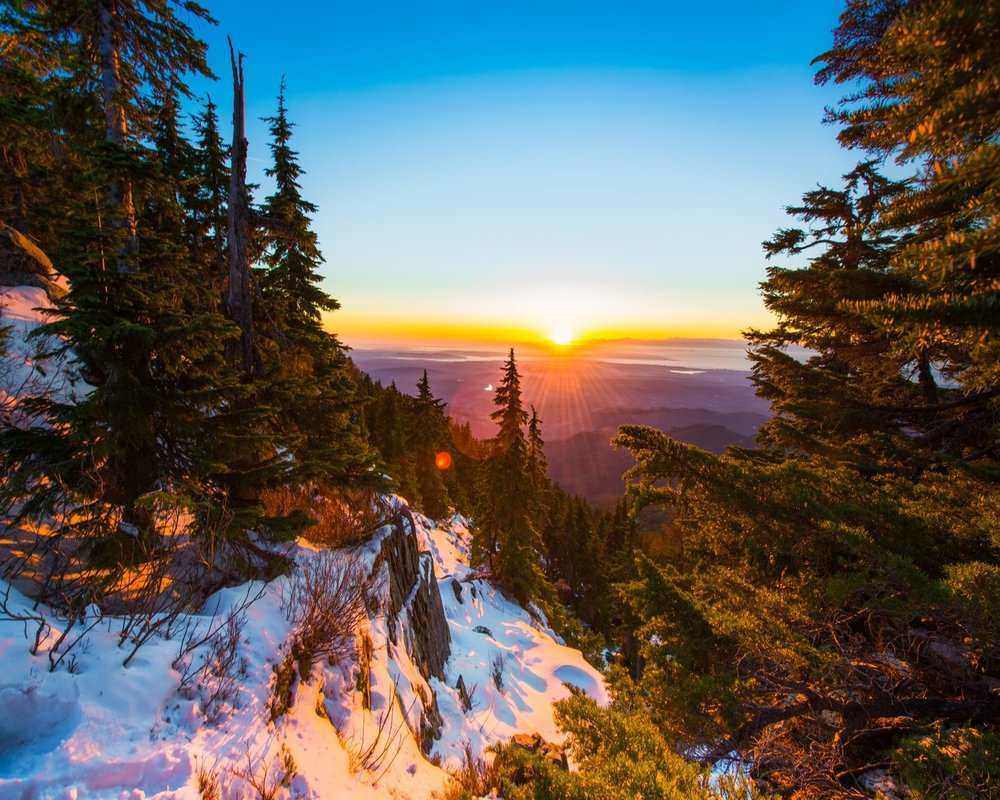
Seattle is the rare big city where you can be standing on a ridge with the Cascades in front of you and the skyline behind you, 45 minutes after leaving your front door. Rock canyons, waterfalls, old-growth forest and alpine lakes are all inside a comfortable day trip.
These are the 11 best hikes near Seattle, sorted easy to difficult, with distance, elevation gain, drive time and where to stay near each one. Pick by how much climbing you’re in the mood for.
TL;DR
The best hikes near Seattle run from a 20-minute city park stroll to a 4,000 ft (1,219 m) climb, and almost all of them are within 90 minutes of downtown.
Best easy hike near Seattle
Rattlesnake Ledge, 4 miles (6.4 km) and 1,200 ft (366 m) of gain, 40 minutes east of the city, with a lake to swim in at the bottom.
Best scenic hike near Seattle
Maple Pass Loop in the North Cascades: alpine lakes, larches and high peaks the whole way around. It’s a 3-hour drive, and the drive is part of the reward.
Best hard hike near Seattle
Mailbox Peak, 9.6 miles (15.4 km) and 4,000 ft (1,219 m). There is an actual mailbox at the summit. Bring something to put in it.
Most popular
Mount Si, which sees around 100,000 hikers a year. Go on a weekday or in late fall if crowds aren’t your thing.
Do you need a car?
For Discovery Park and Poo Poo Point, no. For almost everything else, yes.

The 11 Best Hikes Near Seattle, Compared
Every distance below is round trip, and every elevation figure is gain unless it says otherwise.
| Hike | Level | Distance | Elevation gain | Drive from Seattle | Best for |
|---|---|---|---|---|---|
| Rattlesnake Ledge | Easy | 4 mi (6.4 km) | 1,200 ft (366 m) | 40 min | A first big view, and a swim after |
| Twin Falls | Easy | 2.6 mi (4.2 km) | 500 ft (152 m) | 40 min | Waterfalls, and hiking in the rain |
| Discovery Park | Easy | Up to 5 mi (8 km) | Up to 350 ft (107 m) | 20 min, or take the bus | Families, and no car |
| Ebey’s Landing | Easy to moderate | Up to 5.6 mi (9 km) | 310 ft (94 m) | 1 hr plus a ferry | Coastal views and wildlife |
| Mt. Pilchuck | Moderate | 5.4 mi (8.7 km) | 2,300 ft (701 m) | Just over 1 hr | A summit and a fire lookout |
| Poo Poo Point | Moderate | 3.8 to 7.2 mi (6.1 to 11.6 km) | Up to 1,858 ft (566 m) | 30 min, or take the bus | Year-round hiking, paraglider watching |
| Maple Pass Loop | Moderate | 7.2 mi (11.6 km) | High point 6,995 ft (2,132 m) | 3 hrs | The most scenic of the eleven |
| Snow Lake | Moderate | 7.2 mi (11.6 km) | 1,670 ft (509 m) | 50 min | An alpine lake, and snowballs in July |
| Mount Si | Difficult | 8 mi (12.9 km) | 3,150 ft (960 m) | 45 min | Training, and the Seattle skyline |
| Mailbox Peak | Difficult | 9.6 mi (15.4 km) | 4,000 ft (1,219 m) | 45 min | The hardest day of the eleven |
| Mount Dickerman | Difficult | 8.6 mi (13.8 km) | 3,875 ft (1,181 m) | 1.5 hrs | Old-growth forest and 360-degree views |
Easy Day Hikes Near Seattle
1. Rattlesnake Ledge, Snoqualmie Pass
4 miles (6.4 km) round trip | 1,200 ft (366 m) gain | 40 minutes east of Seattle
Rattlesnake Ledge starts at Rattlesnake Lake near North Bend and climbs steadily to a rock ledge with wide-open views over Snoqualmie Pass and the southern Cascades. The first mile is switchbacks through pine forest, and it never gets properly steep.
It’s the hike most Seattleites send a visiting friend on, which means weekends in summer are busy. Hike a few minutes past the main ledge to one of the higher viewpoints and you’ll have it mostly to yourself, with a better view. The drop-offs are steep, so stay back from the edge.
Bring plenty of water, and save time at the end for a swim in the lake before you drive back into the city.

Where to Stay Near Rattlesnake Ledge
Top pick: Elk River Estate, North Bend. A one-bedroom lodge with a full kitchen, a patio over the river and free parking, about an hour from the trailhead and within reach of several other trails here. It’s a good base for a weekend rather than a single hike.
2. Twin Falls, Olallie State Park
2.6 miles (4.2 km) round trip | 500 ft (152 m) gain | 40 minutes east of Seattle
Don’t let the 500 ft fool you. Twin Falls is short but reliably muddy and wet, so this is the one to wear good shoes on rather than your trail runners.
The reward is a waterfall that cuts through a narrow rock canyon and then drops a final 135 ft (41 m). It’s one of the few hikes here that’s arguably better in the rain.
You’ll need a Discover Pass to park, and the lot fills early on summer weekends, so expect to park down the road and add a few minutes to the trailhead.
Where to Stay Near Twin Falls
Top pick: Salish Lodge & Spa, Snoqualmie. The lodge from the opening credits of Twin Peaks, perched above Snoqualmie Falls in the foothills of the Cascades. Big rooms, an award-winning spa and a dining room with the view. This is the splurge on the list, and it earns it.
3. Discovery Park, Seattle
Up to 5 miles (8 km) | Up to 350 ft (107 m) gain | 20 minutes from downtown, or the 19, 24 and 33 Metro buses
Discovery Park is a former army post turned into Seattle’s largest green space, and it’s the best hike near Seattle for anyone without a car. Seven of its eight trails are easy, and all of them are under 5 miles (8 km).
The one to do is the 2.8-mile (4.5 km) Loop Trail, which runs through woods and meadow to a bluff above Puget Sound with the downtown skyline laid out across the water. Add the drop down to the beach and the lighthouse if you want more mileage.
It’s a family favorite, so weekends are lively. Mornings are quiet.

Where to Stay Near Discovery Park
Top pick: Graduate Seattle. A pet-friendly hotel in the U District with free bikes to borrow, a 24-hour gym and a rooftop bar looking out over the city. The decor is cheerfully over the top and the rooms are bigger than most downtown.
4. Ebey’s Landing, Whidbey Island
Up to 5.6 miles (9 km) | 310 ft (94 m) gain | About an hour north, plus the Clinton ferry
This is the coastal one, and it’s worth the ferry. The trail runs along a bluff on the western shore of Whidbey Island with the Olympic Mountains across the water and the Strait of Juan de Fuca below. Mount Baker sits on the horizon to the east, and the Cascades run away to the south.
Park at the Prairie Overlook Trailhead. The lot across from the cemetery has the better view of the two. The bluff section is where you’ll see bald eagles, seals and sea lions, and in summer sometimes orca. The loop drops to a wild stony beach, then climbs back to the Bluff Trail and returns to the trailhead.
It’s dog-friendly, open year-round, and it sits inside a national historical reserve protecting one of the oldest non-Native settlements in Washington. Of the easy hikes here it asks the most of you, so call it easy to moderate.

Where to Stay on Whidbey Island
Top pick: Captain Whidbey Inn, Coupeville. Built in 1907 and still full of old-world character, with a library, bike rentals and a restaurant and bar open daily. It’s the obvious base for Fort Ebey State Park as well.
Moderate Day Hikes Near Seattle
5. Mt. Pilchuck
5.4 miles (8.7 km) round trip | 2,300 ft (701 m) gain | Just over an hour from Seattle | Best June to October
This is the best one-day summit near the city. It’s on the Mountain Loop Highway, and the climb takes you through old forest and across big boulder fields to a restored fire lookout tower on the summit. From up there you can see the North Cascades, the Olympic Peninsula, Puget Sound and Mount Rainier.
It’s graded moderate, but the gain comes fast for the distance and plenty of people would call it hard. The payoff is proportionate. Because the trailhead takes effort to reach, you get the views without the Mount Si crowds.
Expect mud and snow patches even in midsummer, so dress for it and wear boots with real traction for the rock. The last stretch is crushed stone with potholes, so watch your footing when you’re tired. In winter it becomes a snowshoe route.

Where to Stay Near Mt. Pilchuck
Top pick: Treehouse Place at Deer Ridge, Snohomish. Rooms with private balconies over the garden, a terrace, a barbecue, bike rentals and ski storage in winter. It’s a genuine retreat rather than a place to sleep between drives.
6. Poo Poo Point, Tiger Mountain
3.8 to 7.2 miles (6.1 to 11.6 km) | 1,760 to 1,858 ft (536 to 566 m) gain | About 30 minutes from Seattle | Year-round
The name comes from the sound of the steam engine whistles loggers used to hear on this side of Tiger Mountain, and no, you won’t forget it.
There are two routes up. The Chirico Trail is 1.9 miles (3.1 km) each way and steep. The High School Trail is longer with a gentler grade. Both finish at the same place: an open launch meadow with views across Issaquah and Lake Sammamish toward Bellevue, with Squak and Cougar Mountain to the west and a sliver of the Seattle skyline beyond.
Poo Poo Point is one of Washington’s busiest paragliding launches, so you can sit with a snack and watch people run off the hill all afternoon. The trail is open year-round, dogs are welcome on a leash, parking is easy, and there’s public transit from Seattle if you don’t mind a short hike at the other end. Pick a clear day.

Where to Stay Near Poo Poo Point
Top pick: SpringHill Suites Seattle Issaquah. Straightforward, comfortable and close, with daily breakfast, a gym and an indoor pool. It’s also well placed for Squak Mountain State Park.
7. Maple Pass Loop, North Cascades
7.2 miles (11.6 km) loop | High point 6,995 ft (2,132 m) | About 3 hours from Seattle | Best July to October
This is the most scenic hike near Seattle, and it’s the furthest. You need an early start, and the drive up the North Cascades Highway is good enough that it counts as part of the day out.
The loop starts at the Rainy Pass trailhead and climbs through alpine meadow, past clear mountain lakes, to a ridge with the high peaks of North Cascades National Park all around you. You can hike it in either direction. Most people go counterclockwise, which gets the steeper climbing done first.
There’s an optional 2-mile (3.2 km) add-on that takes you down to see more of the lakes, which is lovely as long as you’ve budgeted the time to get back to Seattle. Fill your water bottle before you start, and bring the dog if you have one, on a leash.

Where to Stay Near Maple Pass Loop
Top pick: Mountain Shadow Duplex. A self-catering unit with a full kitchen, a smart TV and a terrace with garden views, plus a barbecue in summer. Staying out this way is what makes an early start on the loop realistic.
8. Snow Lake, Snoqualmie Pass
7.2 miles (11.6 km) round trip | 1,670 ft (509 m) gain | About 50 minutes from Seattle | Best July to September
Snow Lake lives up to its name. It’s one of the last trails in Washington to clear each year, and the lake itself is a deep sapphire blue sitting in a bowl of rock.
The trailhead is in the Alpental ski area parking lot, which makes it one of the easiest to find. The trail usually closes in midwinter because of avalanche risk, but from July onward it’s one of the best value climbs near the city: a real alpine lake for not much elevation.
There’s often still snow near the top in early summer, which kids tend to consider the main attraction. Watch the signs at the junctions, and check conditions before you go if you’re hiking outside the main season. At the lake you can turn around or carry on a few more miles.

Where to Stay Near Snow Lake
Top pick: Mother in Law Suite, North Bend. A one-bedroom vacation home a few minutes from Snoqualmie with a full kitchen, private parking, a patio and a hot tub, which is exactly what you want after a long day on the trail.
Difficult Day Hikes Near Seattle
9. Mount Si
8 miles (12.9 km) round trip | 3,150 ft (960 m) gain | 45 minutes from Seattle | Best April to November
Mount Si is the most popular hike near Seattle, with something like 100,000 people a year on it. That’s partly the view and partly the convenience: 45 minutes from the city, well-maintained trail, and everyone you meet has done it and will tell you about it.
All 3,150 ft (960 m) of gain comes in the first 4 miles (6.4 km), so this is a genuine workout and the reason half of Seattle uses it as training. Past the switchbacks you get Mount Rainier, the Seattle skyline, a long row of Cascade peaks and, on a clear day, the Olympics.
Most of the trail is shaded, and parts get slippery in wet weather, so wear proper footwear. The summit ends at the Haystack, a rock scramble that is optional and gets slick. Dogs are welcome on a leash if they’re up for the climb. Bear sightings happen, though they’re rare, and carrying bear spray in your day pack is never wasted. For a quieter version of the same hike, come in late fall.

Where to Stay Near Mount Si
Top pick: Hampton Inn & Suites Snoqualmie. Air-conditioned rooms, an indoor pool, a gym, wifi throughout and a hot breakfast, which turns a day hike into an easy weekend.
10. Mailbox Peak
9.6 miles (15.4 km) round trip | 4,000 ft (1,219 m) gain | 45 minutes from Seattle | Best May to October
Mailbox Peak is the hardest hike near Seattle, harder than Mount Si, and it’s the one North Bend locals use to find out how their training is going. It’s worth doing some strength work before you take it on.
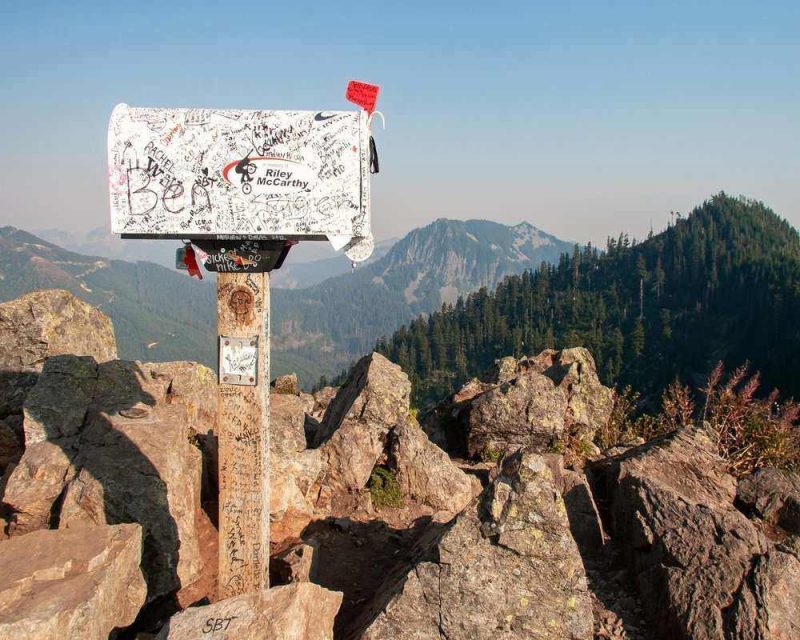
There’s an actual mailbox at the summit, carried up there by a mail carrier in the 1960s. Hikers leave things in it, so bring a small souvenir to add, ideally one that won’t outlive the mountain.
Two routes go up. The old trail climbs about 4,000 ft (1,219 m) in 3 miles (4.8 km), which is exactly as steep as it sounds. The new trail, opened in 2014, is longer, safer in places and spreads the gain out enough to be enjoyable. Either way you finish with a 360-degree view of the central Cascades and a photo with the mailbox.
Much of the trail is under tree cover, but the boulder field near the top is fully exposed, so bring sun protection. Dogs are welcome on a leash if they’re genuinely fit for it. Wildflowers are good here in season.
Where to Stay Near Mailbox Peak
Top pick: Salish Lodge & Spa again. After 4,000 ft (1,219 m) of climbing, the spa is less of a luxury and more of a medical necessity.
11. Mount Dickerman
8.6 miles (13.8 km) round trip | 3,875 ft (1,181 m) gain | About 1.5 hours from Seattle | Best July to October
Mount Dickerman is on the Mountain Loop Highway in the North Cascades, and it’s the most technical of the eleven. It’s further out than most, and the views at the top are the reason people make the drive anyway.
Nearly 4,000 ft (1,219 m) of gain buys you a lot of variety: old-growth forest at the bottom, traverses above cliffs in the middle, and open alpine meadow near the top. There’s real exposure in places, so wear solid hiking boots and pace yourself.
On a clear day you get the Monte Cristo peaks and most of the Cascades. It’s also a good bird-watching trail. Experienced hikers sometimes go partway before July, but you’ll meet snow and ice, so bring the gear for it. Check for trail closures before you set out.

Where to Stay Near Mount Dickerman
Top pick: Best Western Sky Valley Inn, Monroe. A seasonal pool and hot tub, air-conditioned rooms with a microwave, mini fridge and coffee, and free wifi. Simple, and the closest reliable base to the Mountain Loop Highway.
The Best Scenic Hikes Near Seattle, If You Only Have Time for One
All 11 of these are scenic. These three are the ones worth planning a day around:
- Maple Pass Loop for high alpine scenery: lakes, meadows, larches in October and the North Cascades in every direction. The best scenic hike near Seattle, as long as you’re willing to drive three hours.
- Ebey’s Landing for the coast: a bluff above the water with the Olympics across it, eagles overhead and orca offshore in summer. It’s also the easiest of the three.
- Mt. Pilchuck for the summit view: a fire lookout with Rainier, the Sound and the Olympics from one spot, and a fraction of Mount Si’s foot traffic.
How to Get Around Washington State
Some of these trailheads are served by public transit, Discovery Park and Poo Poo Point in particular. For everything else, the bus schedule will cost you more daylight than the drive would.
If you don’t have a car, renting one for a couple of days is the single thing that opens up the rest of these trails, especially Maple Pass Loop and the Mountain Loop Highway trails.
Tips for Day Hiking Near Seattle
- Check the passes before you drive out. Several of these trailheads need a Discover Pass or a Northwest Forest Pass. The Washington Trails Association lists which pass each trail needs, plus current conditions.
- Download the map offline. AllTrails works well here, and cell service disappears on most of the Mountain Loop Highway trails.
- Pack for the day you might get, not the one you have. Here’s a day hiking packing list to work from.
- Wear the right hiking footwear. Washington trails are wet, rooty and rocky, and that matters more on the difficult hikes than on the easy ones.
- Start early on the popular ones. Rattlesnake Ledge, Mount Si and Snow Lake all have parking lots that fill before 8:00 am on summer weekends.
- Want more? Mount Rainier National Park is the obvious next step, and the trails there are a level up again.
Hikes Near Seattle FAQs
What is the best hike near Seattle?
The best hike near Seattle depends on what you want from the day. For a first big view with a short drive, it’s Rattlesnake Ledge: 4 miles (6.4 km) round trip, 1,200 ft (366 m) of gain, 40 minutes east of the city. For the best scenery, it’s Maple Pass Loop in the North Cascades, 7.2 miles (11.6 km) of alpine lakes and meadows, three hours out. For a workout, it’s Mailbox Peak, 9.6 miles (15.4 km) and 4,000 ft (1,219 m).
What are the best scenic hikes near Seattle?
The best scenic hikes near Seattle are Maple Pass Loop for high alpine lakes and larches in the North Cascades, Ebey’s Landing on Whidbey Island for coastal bluffs with the Olympic Mountains across the water, and Mt. Pilchuck for a summit fire lookout with Mount Rainier, Puget Sound and the Olympics from one spot. Maple Pass is the longest drive at about three hours and the most spectacular of the three.
Are there good hikes near Seattle without a car?
Yes, there are good hikes near Seattle you can reach without a car. Discovery Park is on the 19, 24 and 33 Metro bus routes and has eight trails, seven of them easy, including a 2.8-mile (4.5 km) loop to a bluff over Puget Sound. Poo Poo Point near Issaquah is also reachable by public transit, with a short hike from the stop to the trailhead. For the Mountain Loop Highway and North Cascades trails you’ll want a car.
What is the hardest hike near Seattle?
The hardest hike near Seattle is Mailbox Peak: 9.6 miles (15.4 km) round trip with 4,000 ft (1,219 m) of elevation gain, 45 minutes from the city near North Bend. The old trail climbs all of that in about 3 miles (4.8 km); the newer trail, opened in 2014, is longer and spreads the gain out. Mount Si and Mount Dickerman are the next two hardest, at 3,150 ft (960 m) and 3,875 ft (1,181 m) of gain.
When is the best time of year to hike near Seattle?
The best time of year to hike near Seattle is July through October, when the high trails are clear of snow and the weather is most settled. Lower hikes like Discovery Park, Poo Poo Point, Ebey’s Landing and Twin Falls work year-round. Mount Si runs roughly April to November. Snow Lake and the North Cascades trails usually need July or later, and Mt. Pilchuck becomes a snowshoe route in winter.
Do you need a permit or pass to hike near Seattle?
You need a parking pass for most trailheads near Seattle, though not a hiking permit. State park trailheads such as Twin Falls need a Washington Discover Pass, and national forest trailheads along the Mountain Loop Highway and in the North Cascades generally need a Northwest Forest Pass. Discovery Park, inside the city, needs neither. Check the Washington Trails Association listing for the specific trail before you drive out.
Which hikes near Seattle are dog friendly?
Dog-friendly hikes near Seattle include Ebey’s Landing, Poo Poo Point, Maple Pass Loop, Snow Lake, Mount Si and Mailbox Peak, all with dogs on a leash. On Mount Si and Mailbox Peak in particular, make sure your dog is genuinely fit for the climb: that’s 3,150 ft (960 m) and 4,000 ft (1,219 m) of gain respectively, and much of it is on rock.
What is the easiest hike near Seattle with a good view?
The easiest hike near Seattle with a good view is the 2.8-mile (4.5 km) Loop Trail in Discovery Park, which climbs under 350 ft (107 m) to a bluff above Puget Sound with the downtown skyline across the water, and you can get there by bus. If you’ll drive 40 minutes, Twin Falls is 2.6 miles (4.2 km) and 500 ft (152 m) to a waterfall in a rock canyon.
How busy do the hikes near Seattle get?
The hikes near Seattle get busy on summer weekends, and Mount Si is the busiest of all with roughly 100,000 hikers a year. Rattlesnake Ledge, Snow Lake and Discovery Park also draw crowds. The trailhead lots on the popular trails fill before 8:00 am on a summer Saturday. Weekdays, early starts and late fall all thin things out, and the further-out trails like Mt. Pilchuck and Mount Dickerman are quieter simply because the drive puts people off.
More US Hiking Guides
- 7 Best Mount Rainier Hiking Trails, the obvious next trip from Seattle
- Visit Glacier National Park: Everything You Need to Know
- Hiking in Yosemite: The Best Reason to Visit This National Park
- Hiking in Denali National Park: Why You Should Visit
- Hiking Guadalupe Mountains National Park, Texas
- Hikes Near Las Vegas: The 5 Best Hikes You Have to Do
- The Top 7 Hikes in Death Valley, California
- Northern California Road Trip: A 3-Day Vacation Not to Be Missed
Where to Stay in Seattle
Use the map below to find a place to stay in Seattle. Zoom out to widen the search toward North Bend, Snoqualmie and Issaquah, which put you closer to most of these trailheads.
Eleven hikes, one city, and nothing on the list more than three hours from downtown. Pick one, check the pass, and go make a day of it.
 |
 |